Interview with Streisand Scholar Maria Winters
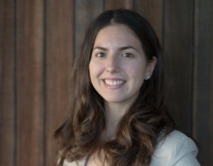 CSW|Streisand Center interviewed Streisand Scholar and PhD Candidate Maria Winters about her research and experience in shoreline restoration and work to protect vital coast communities.
How did you start working on/researching shoreline restoration?
In courses I took as an undergraduate, I learned about the critical impacts of climate change not only on our oceans and planet, but also on humanity, and this profoundly moved me. I also developed a passion for research from undergraduate research experiences and learned about how research influences climate change and sea-level rise policy. For these reasons, I decided to pursue a Ph.D. in coastal engineering.
What have they been working on at the Coastal Flood Lab, particularly any related work as a Streisand Scholar (it might be the same but just in case there’s a distinction)?
My Ph.D. research focuses on the observation and modeling of anthropogenic beach berms or dunes and a novel hybrid substrate living shoreline in southern California. The state of California, and the entire country, is promoting the adoption of coastal restorations, living shorelines, and other nature-based engineering projects for the benefits of protection and ecosystem rehabilitation. Although already utilized widely across the United States, better understanding these structures and improving their resilience is crucial as coastal areas prepare and adapt to rising seas. My work in the Coastal Flood Lab addresses this need.
What about this work is most important to you?
The fact that I am researching much needed solutions to sea-level rise that directly influences policy and real-life coastal projects is what is most important to me about this work. Being from southern California, having the opportunity to work on preserving and protecting beaches here is especially an honor for me.
 What do people need to know about protecting our coastal communities?
There is not a one-size-fits-all solution to sea-level-rise. Coastal adaptation will be different from beach to beach, and from community to community. Coastal protection structures that work on one beach may not be successful on another. This is because each individual beach has different characteristics and sand supplies, different waves that hit it depending on its orientation and location, different geology and surrounding ecology or infrastructure- these mean differences in flooding and erosion and therefore in protection solutions.
There are also many active areas of research in coastal engineering aiming to fill in knowledge gaps crucial to coastal adaptation, such as the physics of how sediment and sand move on beaches. Solutions will also be ever evolving, and adaptive management will likely be required at many coastlines. Therefore, community involvement with future coastal projects is crucial. Additionally, many projects may also be interim solutions until longer term ones are worked out.
Coastal protection also includes preserving our beaches and their unique ecosystems. The field of coastal engineering is fortunately steering away from traditional structures like concrete seawalls that can be devasting to beaches and their ecosystems and is instead researching and implementing nature-based engineering solutions and coastal habitat restoration projects. This is the field of research I will continue to work in after graduate school.
What is an XBeach simulation?
One of the tools that coastal engineers use to predict how water or sand will behave or move on a beach or in an estuary in response to certain tides, waves, or other forcings are models, like XBeach. XBeach is a model used to simulate coastline response to extreme storms or conditions. These models can also be used to tell us how our coastlines will respond to sea-level rise. Some specific questions we can try to answer with these models include: How high on the beach will the ocean reach during the highest tides of the year? How much higher would this be with the addition of sea-level rise? How much will the beach erode after a large storm?
 What’s the most challenging part of your work?
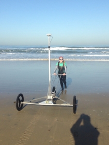
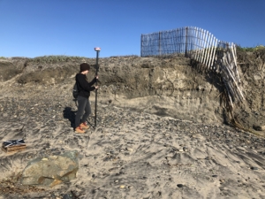
Successfully collecting data on beaches, especially during strong storms and large waves, is one of the most challenging aspects of coastal engineering. It can be challenging physically, such as pushing a GPS-enabled cart directly into breaking waves, jogging a hundred meters, and repeating kilometers at a time to collect surf zone bathymetry. Even something seemingly simple as flying a drone over a beach to collect beach elevation data can be challenging- it is often not possible to get air space approval in highly urbanized areas with many airports like Los Angeles to fly a drone. Data collection, however, is essential to understand how our coastlines change and respond and to understand how successful models are at estimating those responses. Tracking storms that will be impactful on our beaches poses difficulties as well, as wave and surf forecasts only become reliable within a week to a few days. Although these aspects of my work are challenging, they can also be the most exciting.
What does your spring research look like? What will you be working on this upcoming year?
I will be wrapping up a scientific paper about a project I’ve been working on testing coastal models’ abilities to recreate a large 2017 storm event in southern California that resulted in substantial beach dune erosion and backshore flooding. Understanding the performance of these models is crucial to better predict how designed coastal projects will respond and perform. Moving forward I will test other coastal models on more complex living-shoreline structures or nature-based solutions and publish those findings as well!